Digital agronomy,
without the hassle™

A practical, easy-to-use, digital platform that helps you plan, monitor, and analyse your crops and pastures — no downloads, no complex setup, just log in and GROW.
Trusted on over 50,000 farms.
Manage every stage of growing.
Smarter farming from the ground up – plan precisely, monitor in real time, and make confident decisions that drive results.
Plan better.
- Know your land better.
- Identify soil zones and unlock your soil’s potential.
- Know what to apply, how much and where.
- Get the most out of every acre.
- Set up for the best possible season.
Monitor smarter.
- Use satellite imagery to track plant health, detect weeds and disease, and spot issues early.
- Match nutrients with crop demand and reduce where it’s not needed.
- Variable rate in less than 5 minutes. Instant file download so you can load and go.
Analyse deeper.
- Compare strips trial in minutes.
- Review yield maps without the tech headaches.
- Understand what’s working and change what isn’t.
- Pinpoint underperforming areas and take targeted action.
Welcome to the new era of digital farming.
What to use. When to use it.
Plan better
Monitor smarter
Analyse deeper
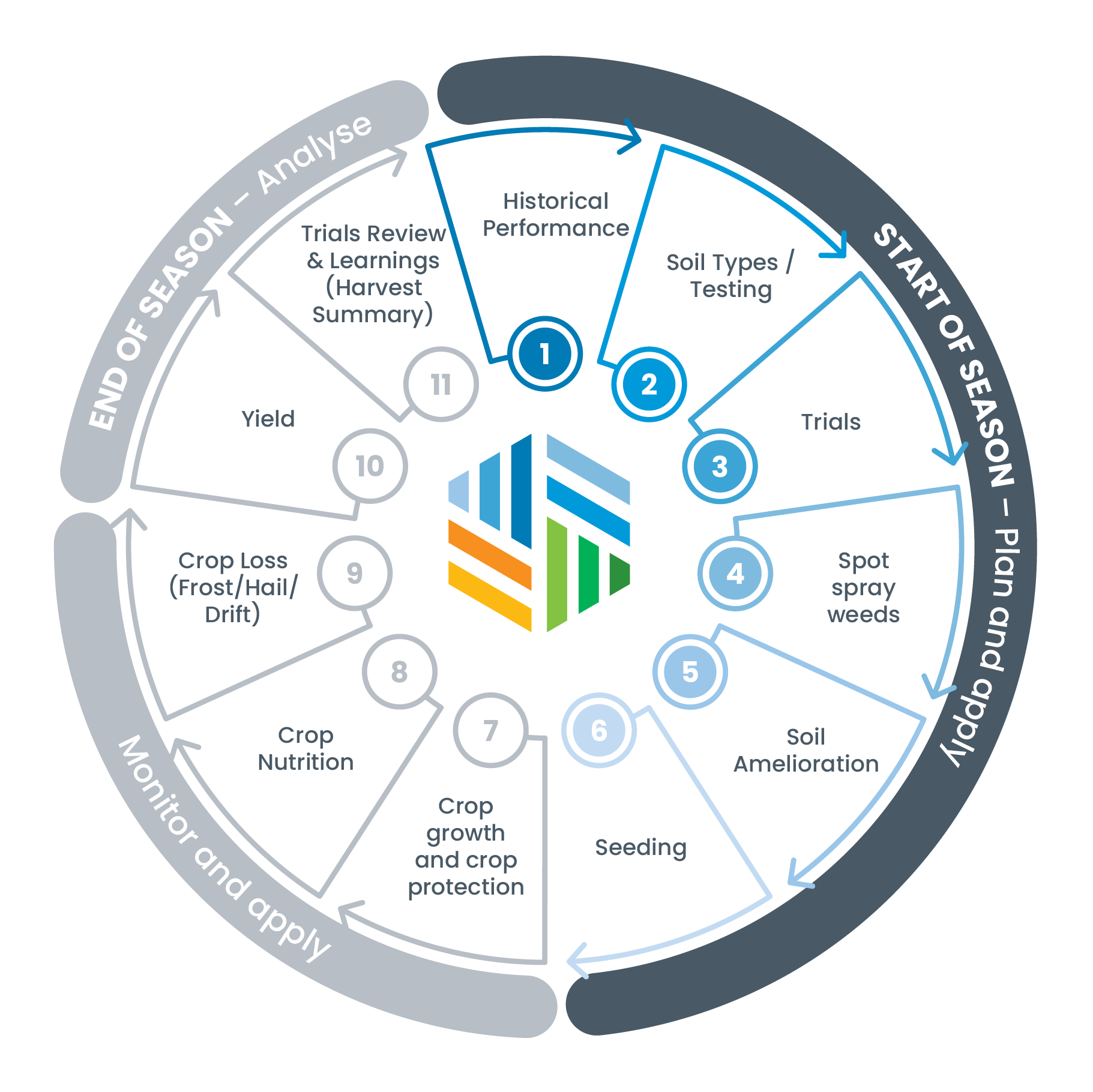
START OF SEASON
Plan and apply
1. Historical Performance
Log inActions:
- Haven’t got organised yield maps? No problem; your farms are already captured with historical satellite data – you get to choose what dates are best for you.
- Review past performance trends over multiple seasons to identify consistent high and low production zones
- What remediation could or should take place?
Tools:
- STACK Analysis
- Create unlimited STACKs in Pro Subscription
- Use STACK to know where to place trials
- Use transparency slider to visualize differences
Access STACK through the DataFarming platform.
2. Soil Types / Testing
Contact UsActions:
- Guide strategic soil sampling based on underlying soil variation
- Use our RapidEM™ or STACK to do your own soil mapping, and inform testing locations and create zones for soil amelioration and fertiliser placement
Tools:
- EM Mapping – Contact us
- STACK Analysis – Log in
Contact us to book a RapidEM™ machine or access STACK through the DataFarming platform.
3. Trials
Get StartedActions:
- Set up trials to test treatments
- Choose the right locations based on STACK or EM layers
- Draw your trial
- Easily monitor ‘hands-free’ during the season
Tool:
- Trials (Available with Advanced or Pro Subscriptions)
Access through the DataFarming platform.
4. Spot spray weeds
Contact usActions:
- Pinpoint Weeds
- Slash Spray Costs
- weedSAT™ maps exactly where weeds are, helping you cut chemical use by up to 80%
- Turn your conventional boom into a spot sprayer
Tool:
- weedSAT™ – Read more
Contact us for more information
5. Soil Amelioration
Get StartedAction:
- Apply lime, gypsum, or ameliorants at variable rates based on EM/Stack zones and test results
Tools:
- Prescription Maps (Variable rate application)
- RapidEM™ Mapping – Read more
- STACK Analysis
Access through the DataFarming platform.
6. Seeding
Get StartedAction:
- Create variable rate seeding maps using productivity zones and soil type variation to optimise plant establishment
Tools:
- Prescription Maps
- STACK Zones
- EM Zones
Access through the DataFarming platform.
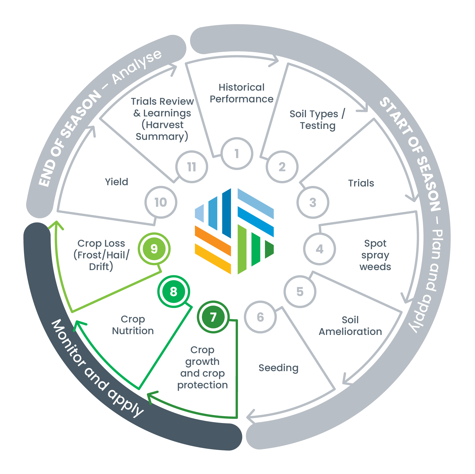
MID SEASON
Monitor and apply
7. Crop growth and crop protection
Get StartedActions:
- Use NDVI satellite imagery to identify variability in crop health and trigger inspections or interventions – pests, weeds, diseases.
- Variably apply fungicides, insecticides, and herbicides with ease.
- Early crop checking can identify establishment issues.
- Monitor each field separately or multiple fields at once and identify problem areas early.
- Use for scouting, issue identification, anomalies in production.
Tools:
- Free NDVI Satellite Imagery
- High-Resolution Imagery (Add-on)
- Variable rate zoning
Access through the DataFarming platform.
8. Crop Nutrition
Get StartedActions:
- Assess in-season plant health and zone fields for in-crop nutrient management.
- Use imagery + tissue test data to refine fertiliser application and or zonal tools at the right crop stage to delineate zones and apply fertiliser applications in crop.
- Nitrogen is critical in canopy management, final grain protein, and yield.
Tools:
- NDVI
- Variable rate zoning
Access through the DataFarming platform.
9. Crop Loss (Frost/Hail/Drift)
Get StartedActions:
- View our frost maps to determine impacted area.
- Review imagery after the event date to identify and measure impacted areas.
- Variation in NDVI can indicate areas of loss. Help find the right locations to check for damage.
- Measuring tools can be used to estimate loss and assist with making decisions, insurance claims, deciding to cut for hay or harvest.
Tool:
- Frost layer
- Satellite Imagery
- Area Tool
- High-Res Imagery (if needed)
Access through the DataFarming platform.
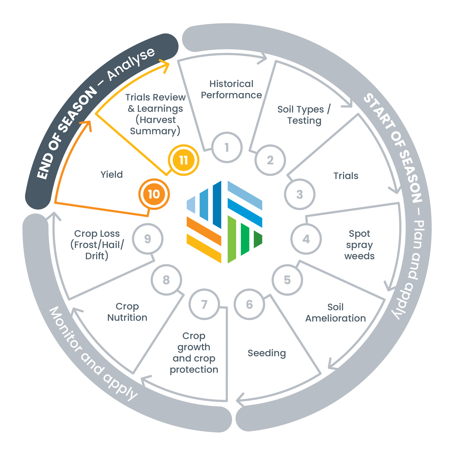
END OF SEASON
Analyse
10. Yield
Get StartedActions:
- Connect to John Deere (and others) and import yield data automatically.
- View and assess final performance.
- Compare with prescription zones to assess effectiveness.
Tools:
- Yield Analysis
- STACK
- Prescription Map Overlays
Access through the DataFarming platform.
11. Trials Review & Learnings (Harvest Summary)
Contact UsActions:
- Overlay trial results, yield maps, satellite imagery and STACK data to evaluate outcomes and inform next season's strategy.
Tools:
- Field Trials
- STACK
- Yield Analysis
- Satellite NDVI imagery
Access through the DataFarming platform.
Why Agronomists and Growers Choose DataFarming
Free access to basic features with flexible pay-per-use premium features or subscriptions designed to suit your needs.
Built to be used by busy growers and advisors — no steep learning curve or software installs.
Access data anywhere, anytime — in the paddock or from the office.
DataFarming's impact.
65
Million hectares
330,000+
Paddocks/Fields
53,000+
Farms
Precision agriculture should be affordable and easy to use.
That’s our motto, and the reason we build simple, low cost precision agriculture solutions that can be incorporated into your daily activities. From your free farm map with NDVI to high resolution satellite imagery, and from variable rate files to a multi-year view of paddock performance. No software or upfront payments. You simply pay for what you need, as you need it. Australia’s most popular precision Ag software.

DataFarming is proudly
Australian owned and family run.
25
Million hectares
275000+
Paddocks
50000+
Farms
Precision agriculture should be affordable and easy to use.
That’s our motto, and the reason we build simple, low cost precision agriculture solutions that can be incorporated into your daily activities. From your free farm map with NDVI to high resolution satellite imagery, and from variable rate files to a multi-year view of paddock performance. No software or upfront payments. You simply pay for what you need, as you need it. Australia’s most popular precision Ag software.
DataFarming is proudly Australian and family owned

Award winning technology
2023
Best in Broadacre Award
2023
Australia's
Best AgriTech Award
2023
Elders Innovation in Technology Award
2021